 M. M. O’Shaughnessy is the engineer who built the backbone of the San Francisco we know today. Think Robert Moses in New York without the colossal ego and disregard for people. Among his enduring legacy of public works in our city, count 68 miles of Muni streetcar lines (including the J, K, L, M, and N lines), the Twin Peaks Tunnel from Castro to West Portal, the Sunset Tunnel under Buena Vista Park, the Stockton Tunnel, the Great Highway, and his crowning achievement, the Hetch Hetchy project, which still supplies the city and the Peninsula with its water.
As part of the current exhibition All the Way Down Market at our San Francisco
Railway Museum, we’re displaying a map of San Francisco’s street railways drafted for
O’Shaughnessy in 1921. The original was donated to the museum by the
family of the late James Adler.
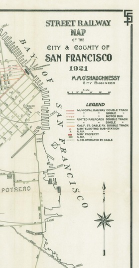
The 16 x 20 inch map shows all the streetcar lines and cable car lines operating in the city almost 90 years ago, along with the few bus lines then in existence. The corners have a distinctive intertwined “SF”, almost anticipating the Giants’ logo still more than a third of a century in the future! It also includes radii drawn at one-mile intervals from the Ferry Building which was, of course, the center of the known transit universe at the time. The map has sparked a lot of conversation along with requests to buy reproductions of it.
In response, we have created a limited edition reproduction of 100 of this fascinating map, in the same 16 x 20 inch size, scale, and colors as the original. It is printed on archival-quality mat board, highly suitable for framing. It will make a great conversation piece on your wall and a dandy holiday gift for any San Franciscan or city lover.
This exclusive map is available for $39.95 (10% off for our members) only at the museum, 77 Steuart Street, (open daily except Monday, 10 a.m. – 6 p.m.) with all proceeds benefiting Market Street Railway’s mission of preserving historic transit in San Francisco.
We’ve included a sliver of the map here so you can get an idea of what it is. We hope you’ll drop by the see the whole map, plus our exhibit of then-and-now photos documenting 150 years of rail transit on Market Street. And while you’re in, don’t forget to pick up our new 2011 calendar!
This is just the sort of stuff that would look good in my apartment, but for one critical problem: I don’t have any room. People need to figure out how to sell virtual space, the space we all need to buy the stuff we want, but don’t have to display it. No, I am not going to rent a storage space. But, this would look so good with my realtor’s map from the early sixties…
This map is fascinating and the limited edition reproduction is a very good idea!