While National Park lands are a major destination of the planned streetcar extension to Fort Mason, connecting western Fisherman’s Wharf to regional transit and the rest of the waterfront is a big benefit as well. Market Street Railway illustration, Robert Campbell photo.
Did the F-line split Fisherman’s Wharf in two? Anecdotal evidence suggests it might have, albeit accidentally, to the detriment of the western part of the Wharf area. But a solution is at hand: an extension of vintage streetcar service westward to Aquatic Park and Fort Mason, a project now in environmental review. This project, currently led by the National Park Service with strong Muni support, promises very positive impacts for the western Wharf area as well.
Changing Historic Patterns
Fisherman’s Wharf is San Francisco’s biggest visitor attraction. As such, it’s a critical part of the city’s economy, in good times and bad. Until the late 1960s, what people referred as ‘the Wharf’ was almost literally that: the boat harbor next to Pier 45 that was home to the city’s fishing fleet, crewed mostly by Italian immigrants and their descendents. The string of restaurants surrounding the harbor was included and not much else.
But in 1957, Muni realigned its cable car service, piecing together parts of two lines to make a new ‘Powell-Hyde’ line that, for the first time, directly linked the heart of the city’s retail and hotel district to Aquatic Park. Tourists just wanting a cable car ride happily climbed on board the Hyde cars only to find an empty dirt lot at the other end, along with a bunch of industrial buildings.
But this new, visitor-friendly historic transit line soon helped inspire visionary developers, including William Matson Roth and Leonard Martin, to convert some of those old industrial complexes into shining new retail attractions such as Ghirardelli Square and The Cannery. Gradually, the definition of ‘Fisherman’s Wharf’ expanded, in the minds of both visitors and merchants, to stretch from Ghirardelli in the west all the way to Pier 39, developed in the late 1970s, in the east.
The two cable car lines distributed public transit visitors evenly across the western and central parts of the Wharf. (The Powell-Mason line’s terminal at Bay & Taylor has served the area since 1888.) The eastern edge of the Wharf area, anchored by Pier 39, counted mostly on automobiles to bring its visitors, as clearly evidenced by the enormous garage adjacent to the facility.
When the F-line opened to the Wharf in 2000, visitor travel patterns changed again. Now, in addition to the two north-south cable car lines reaching the Wharf, there was attractive east-west vintage rail service directly linking downtown via The Embarcadero, where it replaced an infrequent Muni bus that no one rode.
Looping through much of the Wharf on Jefferson Street heading west and Beach Street heading east, the F-line was an immediate hit with riders and today carries far more people than the Powell-Mason and Powell-Hyde cable car lines combined. Some of the F-line ridership has come at the expense of the cable cars (the $5 cable car fare and long turntable lines in summer no doubt play a role in this), but most F-line riders appear to be people who otherwise would have either taken a private automobile or a taxi. Bottom line, though, the F-line has made it easier and more attractive for people to reach the Wharf. At least part of it.
When people ride into the Wharf area on F-line streetcars, they pass sights they’ve seen or heard of before. Pier 39. Restaurant Row. And, just before the Jones Street terminal, the fishing fleet’s harbor. So, the strong temptation when getting off the streetcar is to walk back to explore these attractions, rather than walking westward. Watch where people go when they get off the F-line cars at the terminal and this pattern becomes visible. Similarly, visitors who start their Wharf visit at Pier 39 and walk westward often stop when they see the F-line terminal at Jones and take the streetcar back downtown, figuring (wrongly) that the end of the line is the end of the attractions. Given this, perhaps it is not so surprising that some attractions in the western part of the Wharf have seen static or declining visitation since the F-line opened.
Back to ‘Plan A’
There’s a little irony in this, because Muni’s original plan for historic streetcar service, dating back to 1979, called for the line to go all the way through the Wharf — past it, in fact, to use the 1914 railroad tunnel to reach Fort Mason Center.
But by the time planning for the F-line extension began in earnest, the originally proposed Fort Mason terminal had been pulled back to the central Wharf area for a variety of reasons, not the least of which was opposition to the whole streetcar concept by some wharf merchants concerned about losing a handful of automobile parking spaces.
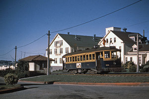
Muni’s H-line ran through Fort Mason from 1914 until 1948, but never connected it directly to Fisherman’s Wharf. The streetcar shelter (left) is still there, as are the buildings, now National Park Service Headquarters for the Golden Gate National Recreation Area. Bob McVay photo, Walter Rice collection.
Now, wharf merchants unanimously support the F-line and are calling for additional service to handle the demand, which at 23,000 daily riders is way beyond Muni predictions.
Seven years ago, the then-executive director of the Fisherman’s Wharf Merchants Association, Al Baccari (now a member of Market Street Railway’s advisory board) began lobbying to implement Muni’s original plan of streetcar service all the way to Fort Mason. His reasons? The Fort Mason Center area had grown steadily in popularity through its mix of performing arts venues, galleries, and exhibition space, to attract more than 1.5 million visitors annually, despite no direct Muni connection to the Wharf or Downtown. Many of those Fort Mason visitors, Baccari reasoned, would take an attractive streetcar to get there, stopping to eat or shop at the Wharf on the way. The Wharf would also gain a quick attractive connection to Fort Mason’s ample affordable meeting space, helping its hotels attract more conference business.
That spark of interest from Wharf merchants was enough to rekindle the proposal. The National Park Service, as part of a park master plan, had been reserving the abandoned — but intact — 1914 railroad tunnel between the foot of Van Ness Avenue and Fort Mason Center for rail transit. The Park Service also saw how attractive streetcar service would provide a pollution-free alternative for visitors to reach its San Francisco Maritime National Historical Park, enabling children and families from all over the Bay Area to reach the park easily on public transit. It would also give them the ability to expand visitor capacity without having to expand parking. This too, helps merchants in the western Fisherman’s Wharf area.
Rebalancing Wharf Transit
The extension has the important benefit of reunifying the pieces of Fisherman’s Wharf by rebalancing transit access between its eastern and western portions. After studying several possible east-west alignments of the extension, Beach Street was selected as the route for environmental and historic preservation reasons. Among other advantages, this allows the placement of streetcar stops in both directions directly opposite the Hyde Street cable car turntable, providing a mini-transit hub to visitors wishing explore the Wharf area. The streetcar tracks alone provide a clue to visitors getting off the cable cars that there’s something to see where the tracks lead.
Going east from Hyde, the tracks pass The Cannery and the foot of Columbus Avenue, gateway to North Beach, and then continue on Beach to connect to the existing F-line track at Jones. (Coming west on Jefferson from the current Jones Street terminal, the extension would go west to Leavenworth, then swing one block south to meet the eastbound line at Beach.)
Going west from Hyde, the extension’s track reaches Ghirardelli Square and the Maritime Museum, now undergoing a multi-million dollar renovation by the National Park Service. Indeed, a key reason for such strong support of the extension by the Park Service is the exposure streetcar riders will get to the San Francisco Maritime National Historical Park (including the Maritime Museum, Aquatic Park, the Hyde Street Pier’s historic ships, and Municipal Pier).
Along with the tracks, the streetcar extension will bring the existing F-line’s upgraded streetscape to the western Wharf on the streets it follows, including ornamental streetlights/trolley wire supports and passenger boarding areas. This further reunites the Wharf area visually.
Moving Forward
Market Street Railway has been closely involved with the extension planning process since it began, serving as an advocate and facilitator through a role on the technical advisory committee created by the National Park Service, which is leading this phase of the project.
An Environmental Impact Statement is underway and once a draft is published, public comment will open to take feedback. Though it has been slow, the project continues to progress.
Earlier expected to be operated as an extension of the forthcoming E-Embarcadero line running along The Embarcadero from Mission Bay to Fisherman’s Wharf, Muni now considers it possible that rider demand would cause the extension to be operated as part of the more frequent F-line instead, with the E-line terminating at Jones Street. (Either way, both the E and F lines would operate between Jones Street and the Ferry Building.) Further study, public comment, and operating experience will inform the ultimate operating decisions.
Whatever the operating details, a vintage streetcar extension would clearly help reunite Fisherman’s Wharf in addition to its many benefits to the National Park Service, which has funded the studies and would fund much of the project construction as well. The core construction costs are estimated at around $30 million, not counting contingency, plus $10 million for a seismic retrofit of the tunnel, which is planned to be funded separately. Five million dollars of the extension project has already been funded; additional funding is being sought from sources that do not conflict with such Muni priority projects as the Central Subway. Depending on funding availability, the extension could be carrying passengers by 2014.
As of 2010 planning work continues slowly, but steadily, despite SFMTA budget troubles. Market Street Railway will continue advocating for this and other historic transit projects with the support of our members.

This is a nice idea, but they’ve been talking about it for decades. Is there any reason to realistically think it will actually happen in our lifetimes?
Its too bad the proposed extension apparently won’t be using the existing track along Jefferson Street that continues north of the Maritime Museum adjacent to the water. That would have been nice.
I haven’t looked at the existing track lately, but if it’s left over from the Belt Railway operation, there might be a problem with running streetcars on track designed for main line freight cars. It can be done with care, but for a full time streetcar operation, building track specifically for narrow-wheeled cars might be necessary. Another problem with old track is that it may have been cut or removed in several places; when does tying the “chunks” together become more of a pain than just building it fresh?
I looked at the map again, and wondered, how much of a civil/mechanical engineering challenge will it be to have the electric streetcar track crossing the cable railway at Hyde St. Will the design team dust off hundred-year-old blueprints, or will in turn into a case of ignoring the voices of experience and re-inventing the wheel (or the railway)? For example, didn’t Cal Cable cross the Muni line on Van Ness?
Would it be possible to run the T-Third extension with the F-Line through Fort Mason, kind of a backup/supplemental connector from Fort Mason to Downtown?
Our lifetime…yes…there are multiple constituencies pulling for it…and the price tag is small beans.
While the promenade tracks would be really cool (I mean REALLY COOL!), operational issues militate against that right of way. Pedestrian conflicts, seismic issues, all sorts of things make it kinda impractical. Absent funding issues, I always thought it would be really nice if the rails were connected and overhead was installed, so that occasional exhibition type service could run along the promenade.
Very little of the old Belt Railway track has be cut/removed. For the most part, at worst, it has been paved over.
Technically, a modern LRV could run on the Embarcadero trackage (the overhead is pan compatible), but realistically, it is unlikely to happen. E-line service to Caltrain or Dogpatch is the most likely thing for south of Ferry Building service.
And yes…how awesome will it be to have a CC/Streetcar crossing again!
Sending streetcars through the Fort Mason tunnel and then no further strikes me as silly, especially since it’s a one-track tunnel and therefore would be a bottleneck. I’d much rather have the streetcar line terminate at the Municipal Pier and then open the tunnel for bikes and pedestrians.
I grew up on Chestnut St., in the Marina, from 1950 to 1962, when I joined the Air Force. I rode my bike to Aquatic Park and the Marina Green many, many times. I remember the freight trains running on the north side of the Museum, thru the park, the tunnel and the Marina Green to the Presidio. I chased them or rode along side them. From what I remember, the tracks north of the Museum have been paved over. What they did with the tracks thru the grassy area, I don’t know. They may have been removed. The tracks along the Marina Green were paved over. There was a short section on double track from Buchanan and Webster Streets. My suggestion would be to use as much of this track, for the west bound cars, all the way to the tunnel. Take the east bound cars up to Beach St. to connect with the current F line. But, as Mr. Davis states, some of it may have been removed or may not be useable for streetcars. Crossing the Hyde St. Cable Car tracks should not be that much of a problem. The Powell St. line did just that twice, on Columbus Ave., years ago crossing the orginal F line, and the California line did cross the H line on Van Ness Ave.
Mr. Parks: NO, the LRVs can not run on the F line on the Embarcadero. I have already suggested that. Mr. Laubscher told me the LRVs draw more current then the PCCs and the overhead wiring is NOT useable for the LRVs.
Running thru the tunnel on single track would not be a problem. Put a signal on each end and time the cars so that there would not be a long delay at either end.
I’d love to see this happen. But, I think the floks living along the Marina Green, might have a lot of negitive things to say about this. It would give them one more transit line to ride downtown. Now they only have the #30 Stockton and the #22 on Fillmore Street.
I like how there is some time effort being focused on this. But my main concern is being that what Mr. Davis commented above is that the challenge of operating across the Cable Car tracks on Hyde Street. I mean there would have to be some major overhaul of that section in order for this to work. Wouldn’t it?
Hey wait a minute, didn’t I remember reading something from you guys a couple years back saying there would be some sort of engineering challenges if the E-line, F-line, whatever line it’s called be routed on Beach Street in both directions crossing the Hyde Street trackage which curves into the turnaround?
And Mr. Davis, I did not mean running LRVs on the Embarcadero, I meant whether it would be possible if the Central Subway, which may be routed on Columbus, could meet up on Beach Street and follow the E or F to the Van Ness terminal, of course, that would personally offend the merchants in the area…
Excuse me, I meant Mr. Parks.
I didn’t expect there to be so much concern about streetcar tracks crossing the cable car tracks. From the streetcars’ perspective, this isn’t any different than crossing any other set of tracks (like the F and J lines cross at Market & Church) because they won’t interfere with the cable cars’ grips that go down into the slot. Likewise the cable cars have nothing to do whatsoever with the trolley wire overhead, which run above them all over already.
During the preliminary study, the routing which had the westbound tracks making a sharp right from Hyde onto Beach across both the cable car tracks was found to be unpractical. That left, I believe, 4 other routings on the table to consider which had the westbound tracks merging onto Beach either before or after Hyde. Which is a pretty steep grade as well.
Cable car crossing: this has already had some preliminary engineering done on it, and an alignment for the streetcar tracks has been found that clears the cable pulleys. So it isn’t seen as a problem.
Using the old freight track on the Aquatic Park Promenade: this was rejected during the feasibility study for a number of reasons. The biggest is law: in simplified form, federal statutes make it clear that the “taking” of designated parkland must be minimized when constructing transportation facilities. Using Beach Street in both directions accomplishes that. Additionally, major questions were raised about the structural soundness of the existing installation (it was a WPA Project and the adjacent concrete bleachers are now undergoing a complete restoration at great expense because of substandard construction), and safety considerations associated with mixed streetcar, pedestrian, and bicycle use of what is a narrow promenade (which can’t be widened, again, under preservation law).
Terminating at Municipal Pier instead: Fort Mason Center draws in excess of 1.6 million visitors a year, with inadequate parking. The Park Master Plan calls for rail transit service through the tunnel to serve this demand. The tunnel is not wide enough to accommodate all uses. It is also about 1100 feet long, and even if well lit, not at all welcoming to pedestrians, especially at night. Cutting the line off four blocks short of its primary trip generator and making people walk through a tunnel makes no sense.
Running both T and F lines through tunnel to Fort Mason: the single-track tunnel can be operated safely (with signal interlocks) and efficiently down to a headway of about 6 minutes. This would allow F-line or T-line operation, but not both.
I never understood why the F Line “stopped short” at Jones Street instead of terminating at Leavenworth or even Hyde, although I could see the grade on Hyde between Jefferson and Beach being a problem. Does anyone know how steep the grade is there? (Also, why didn’t the F Line follow the 8 Line down Castro Street and use the 8’s old terminal loop via 18th, Collingwood and 19th streets instead of Noe and 17th?)
I do agree however, that the Marina Extension should NOT run north of the Maritime Museum along Aquatic Park. Aquatic Park is a pedestrian promenade with a beach area that people (children) play in. Even at slow operating speeds, bells and whistles going off, all it would take is a small child tripping and falling, an inattentive parent/guardian (on the cell phone), a distracted (or stressed out) operator, and hello multi-million dollar lawsuit. However, maybe a short spur track could be laid in the dead-end in front the Dolphin Club to exhibit a car or two during the summer or events, in a place more visible and accessible then Dave Pharr Yard. (Or picture this, the old State Roundhouse & Shops becoming MSR’s “Roundhouse Division” combining restoration shops – the roundhouse, and office space – the shop building. Yeah, I know, it’s wishful thinking.) Mr. Poskanzer makes a valid point about having the Marina Extension stopping in Ft. Mason. If it’s going to be done, it should go all the way to at least the Palace of Fine Arts, if not the Presidio.
Even though much the old State Belt trackage still exists, paved over, it would still have to be replaced. The sub-base and ties are most likely shot anyway. Remember that’s all laying on fill with a lot of subsidence and drainage problems. That track is not up to today’s standards and was never intended for an electric railway. The rail joints are probably not bonded with jumpers for electric current.
Also, the overhead on the Embarcadero north of Market and the loop around Hotel Vitale should be made LRV compatible. I understand the desire to have picturesque, vintage cars serving a prime tourist area, but the inflexibility of not being able to accommodate LRVs is a hindrance. A 2-car train of LRVs can carry the load of 3 PCCs/Milanos, something that could be especially useful during special events such Fleet Week, which bring a lot of people to the north side of the City. You only need 1 operator for LRVs (or 1 operator and a “conductor” to take fares aboard the second car) vs. 3 for the PCC/Milanos. When it’s the end of a long day after an event, people are tired and just want to get home. They don’t care if it’s a PCC, LRV, cablecar or bus so long as it gets them there.
All railway overhead, except Market Street (joint use with trolley buses) and the Subway (gapped overhead helps isolate sections during emergencies), should be compatible for either pantographs or trolley poles. All this separation (this vehicle can run on this street but not that street, that vehicle can…) can only make things harder in the long run. Image a fan trip with MSR #798 down 3rd Street, with the car signed for the old MSR 16 Line and not being able to operate south of Metro East Rail Maintenance Facility due to the overhead on Islais Creek Bridge being LRV only ( http://world.nycsubway.org/perl/show?86616 – http://world.nycsubway.org/perl/show?86615 – http://world.nycsubway.org/perl/show?86614), unless someone ‘walks the pole’. What I don’t understand is how come the 4th Street Bridge was built to accommodate both types of current collection but not Islais Creek. If Muni ever completes the K/T circle route via Geneva Avenue, cars with trolley poles transferring from Metro West Complex to Metro East Complex under their power would have to do so via the long route, going all the way downtown, again unless someone ‘walks the pole’ (or Muni rebuilds Islais Creek again).
Is it me or does Muni’s poor short-term planning always negatively affect its long-term planning?
This project seems to be a “when” rather than an “if”, so we may look forward to getting videos of electric and cable-hauled streetcars crossing in the 21st Century. The “ultimate” photo/video catch would be ex-United RR’s single trucker 578 waiting for a Hyde car to cross during a railfan charter or special event.
Rick’s concerns about pedestrian/bicyclist safety in the tunnel are stale. The Marin bike ‘freeway’ is already under construction and will use their tunnels. They dealt with the issue. Is San Francisco now The City That Knows How To Whine?
Actually, though, my preferred solution for a level bike route there is to rehab and extend the abandoned pier next to the Municipal Pier, so that it goes all the way around Black Point and connects to Fort Mason. That would take about 500′ of new pier.
Hi, Mr Garrett C. Garnes,congratulations,you are correct.
Jef, if you mean Marin’s Cal Park Hill Tunnel under construction now (and set to open next year) then you might not be aware the tunnel is significantly wider and the 12″ bike tunnel is being built alongside and completely separated from the SMART rail tunnel. SMART is also providing a good deal of the funding for the bike tunnel. There is more to it than just a tunnel though, another part of the bike freeway includes a bike bridge leading up to the tunnel.
A closer situation to the Fort Mason tunnel is Alto tunnel which connects Mill Valley to Corte Medara. Planning is underway and in that case, the tunnel curves at the end, so several hundred feet of collapsed tunnel will be removed to establish a line of sight from one to the other for safety.
In both cases, the tunnel projects save hundreds of feet of climbing along winding and sometimes very busy roads, where the Fort Mason tunnel doesn’t give you a savings in time or distance (as for the vertical climb, it is pretty gentle compared to a lot of the city and no worse than parts of Golden Gate Park) and it would be a break in an otherwise pretty continuous bayside trail. Begging the question: why would someone want to leave the bay trail (which has a couple really good viewing/photo op spots by the way) to enter a dark tunnel? If the climb is the issue, then I’m with on leveling out the grade if possible.
Back to the entering a dark tunnel and your earlier comment about walking or riding a bike the last mile, there’s also a big issue of discoverability and promoting Fort Mason. Just having streetcar service, especially of the historic bent, will bring more people into Fort Mason automatically. Having “Fort Mason” on the destination signs will be especially good for the businesses and non-profits there, who are short on parking as it is, and will have an easier go at directing to get their by transit instead. That’s going to establish a presence and reason to go beyond Aquatic Park to see what’s there which in turn will draw in more pedestrians and cyclists, in turn creating more demand for better pedestrian and bike access to Fort Mason.
My take is that there is no single better way (and in terms of transit funding, it’s a pretty good bargain at $40M, that Cal Park Hill tunnel is $25M) to connect the Wharves and Aquatic Park on the east side to Fort Mason on the west.
The First Priority: I have read all the above replies and everyone makes a great point but, you are all missing one thing, in my opinion. That is: To get the E line running, MUNI needs to build a wye or a loop somewhere near the Cal-Train Depot. With that in place, the current inventory of PCCs, both single and double ended, and Milan Trams, could run from Cal Train to the short turn loop at Pier 39, thus supplementing the F line during the peak summer months. Using the loop, at Pier 39, would prevent the E line cars being tied up with the F line cars at their terminal, thus providing better service.
Garrett C. Garnes, to answer your grade question, the grade on Hyde Street between Jefferson and Beach is only 8.73%. Of course, streetcars cannot terminate at such steep grade, but why not close to the front entrance to the Argent, or Argonaut, or whatever it’s called.
Dennis, I heard from a Muni operator (probably not a reliable source) that Muni does not intend on building a loop or wye anywhere near Caltrain or in Mission Bay, but, according to sources I’ve seen, the E-line may terminate at a development on Terry Francois and Mission Rock. Not sure what’s the name for the Seawall lot…
Dennis, the T-Third Street plan includes an as-yet-unbuilt loop just south of Mission Bay, intended to turn around Central Subway trains in the future. It could be used for E-Line as well, but more exciting is the Mission Rock redevelopment plan which includes a loop dedicated to the E-Embarcadero line with the terminal right next to a new park.
Hi Dennis Frazier,there´s one loop! it´s not finish though, check 18th st, 19th st, 3rd st, and Illinois st….
The loop in the Mission Rock redevelopment sounds great!! Yes, I did see a photo, of Milan 1818, using the soon to be finished loop, on Illinois Street but, I thought that was too far away from the Cal Train Depot to be of any use for the E line.
Hyde Street was studied as a possible extension route westbound. Problem is not just the grade, though at almost 9% with a right turn at the top, that would be enough to disqualify it alone. It’s the fact that there’s a sheave pit under the middle of Hyde for the cable car terminal. Streetcar can’t go over it, and would essentially pre-empt the whole street to go around it. So Hyde was an early non-starter. Another alternative to the promenade was studied, following Jefferson past Hyde, then angling southwest through Aquatic Park, skirting below the cable car turnaround area, to reach Beach at Larkin. Rejected by the Park Service for the same reason as the Promenade: took more parkland than a two-way Beach alternative.
It was my understanding that the track on 18th, Illinois and 19th streets that was being installed along with the 3rd Street trackage, was planned as a terminal loop for the E Line, so that single-ended cars could be used (which Muni has more of). This also had the advantage of allowing the E Line to penetrate the Mission Bay/Mission Rock Districts. However, several years after the completion of the T Line, only the stub switches onto 18th and 19th streets ( http://world.nycsubway.org/perl/show?101707 ) have been built, no loop. Yet, surprisingly, Armstrong Avenue wye, which can only be used by LRVs, was built. Streetcars with trolley poles cannot operate south of Metro East Rail Maintenance Facility due to the overhead on Islais Creek Bridge (see my comment above for photo links). It seems unnecessary to build a wye to turn double-ended cars ( http://world.nycsubway.org/perl/show?58362 ) when a simple switchback could have easily been installed near Armstrong Avenue for less money. If the funds to build Armstrong wye had been used to build Illinois Street loop instead, then Phase I of the E Line would probably operational by now and double-ended cars would be a plus and not a necessity. Could not the funding to rebuild the double-ended PCCs be re-allocated to the Illinois Loop instead? It seems a better pay-off, four cars for a specialized stub-end terminal vs. a loop terminal that can accommodate the entire fleet (not that I don’t want to see the double-enders operational).
It seems unnecessary to worry about building new loops so or rebuilding perfectly good overhead wire to extend the non-existent E-Line all the way to a non-existent Geneva line when Muni doesn’t even have enough streetcars to keep the F-line running without having to put busses on the line. BART’s Tom Radulovich has even advocated getting rid of it.
Right now, there is still little enough reason for E-line service to Caltrain as it is, and you’re talking about extending to serve parking lots and empty warehouses. Muni spends millions of dollars running empty N-Judah trains to Caltrain off peak, which probably has a lot to do with why Muni only runs the E-line during Sunday Streets. Now with a global recession it’s likely going to be a another decade before South Beach and Mission Bay have enough going on to justify E-line service.
Meanwhile, the Fort Mason has the demand for streetcar service and I’m glad to see the Market Street Railway has taken their head out of the clouds and is now talking about extending the F-line to Fort Mason instead of creating a complicated network that requires a transfer to get from Union Square to Fort Mason. You could be some of the most informed and best advocates for the F-Line, but instead of talking about how to make this happen this discussion is getting into E-line extensions to nowhere and even taking money away from restoration of streetcars to build unnecessary loops.
Lava Rat, we brought up the E-Line ourselves in the post and show it in the graphic and though it was not the main topic of the post and if you wish to disagree with other commenters or us, please do so respectfully.
With that in mind, you raise a good point about the slow development of Mission Bay. Another thing to consider is what kinds of attractions are going to be served and their relationship to each other. Currently what’s built in Mission Bay is the UCSF campus and other office buildings which are not top tourist destinations. Extending service to Fort Mason will connect more entertainment and tourist destinations together. Those destinations are not only along the Embarcadero either, something we wrote about earlier this year:
One of the most important things we’ve learned is that the F-line actually functions as two distinct operations most of the time: a largely residents’ line from Castro to the Ferry Building and a largely visitor line from Fifth Street to Fisherman’s Wharf, the ridership overlapping downtown.
I haven’t lived in the City for many years now. The last time was a three month period in 1966. So, I had to look at my MUNI route map to see where this Mission Rock Project was. I found it just across China Basin from the Giant’s Ballpark. That would be a great place to turn the E line around but, that is going to take a long time to build. In my opinion, MUNI needs to get the E line running, with their current inventory, as soon as possible, to help the F line out with it’s heavy ridership in the summer months. We this in mind, and using the existing LRV tracks, couldn’t a wye be installed at 4th and King Streets?? Or is there already one there for LRVs to use??
Despite the fact that I love our historic trolley cars and ride them often, and despite my initial attraction to the idea, as a Marina resident of some 20 years I view these plans with a wary eye.
Once the route is complete through to Ft. Mason what’s to stop a push all the way to the Presidio? During the fracas over the Fisher museum the Presidio Trust suggested just that and published a plan showing a route through the heart of my neighborhood. No thanks. As marvelous as these cars are they are also very noisy – and they bring tourists. We’ve already seen plans in the past for development on Marina Green. With trolley cars bringing thousands into the neighborhood will we also see increased pressure for more amenities for them? What will be the impact on the Marina District as a whole?
At the moment, Ft Mason provides a natural barrier to the spread of tourism and attendant kitsch into the Marina District. The Green and the area up to the Presidio exists as an untrammeled expanse of grass, boats and vistas, sans the tacky attractions of Fisherman’s Wharf (which has its own particular charm but only in its place, please). It should remain so for future generations of San Franciscans to enjoy just as it is now. As important as tourism is to the city it should not be the prime driver for development.
Other questions rise: what are the exact plans for the western terminus at Ft. Mason? Will there be a turn-around? If so, where will it be placed? Will it impact the slope down from the meadow? Has an Environmental Impact Report been completed, and if so where could one acquire a copy?
If the Park Service and MUNI are intent on this plan I wager they’ll need a lot of fast talking and some iron-clad guarantees before they get the Marina District on board.
Isn’t this the same tunnel Dirty Harry used to beat up some muggers? If so, with them gone it has to be safe to use now.
I’m all for the extension.
Where will the terminal be, Laguna and Marina Blvd, at the tunnel portal?. Will there be no layover tracks?
The terminal would be just to the west of the tunnel portal, inside the boundary of Fort Mason itself. There would be a storage track for at least one out-of-service car and room on the loop for multiple streetcars.
I dream of routing on to Fort Point with a funicular up to bridge level.
The rails did run out there during the bridge construction.
Boy, Ross, you sure think Marina District residents are impotent. I’ll tell you what stops any further extension. Marina residents themselves! You’ve done it dozens of times on projects before.
But hey, how about just being honest and say, “I don’t want streetcars on Marina Boulevard because I paid a lot for this house.” People understand that. It’s a justifiable position to take as a homeowner. But enough with the phony scare tactics. On what basis do you suppose streetcars would spread Fisherman’s Wharf style “attendant kitsch” to the Marina District? Where? From your comments, you’re clearly only concerned about Marina Boulevard, which is completely residential, with nothing but properties administered by Rec & Park on the other side. So where do you fit all that kitch, Ross? Do you decertify parkland? Do you rezone homes on Marina Boulevard into t-shirt shops?
On the other hand, if your real message here is that public parkland really should only belong to the people who live across the street from it, well, that’s another discussion.
Dear Rick Laubscher,
thanks for your response to Ross, I agree wholeheartedly. I would like to know if it would be possible to rebuild the tunnel under Ft. Mason for two tracks for anywhere near the same budget as simply upgrading it seismically.
The short answer is no. The tunnel has a historic designation and changing its size would involve a protracted process. But a single track tunnel with proper signalling should offer adequate capacity. It’s only 1100 feet long, after all.
The F Line (& hopefully E Line) extension through the Fort Mason Tunnel to a terminus at the foot of the Marina Green is a wonderful concept. I am excited that The National Park Service and The City are working together to create smart COOL, fun, historic, and environmentally friendly transportation that is desperately needed in that district.
Its not just for America’s Cup Folks. Its going to come in handy aka be a LIFESAVER YEAR ROUND!
First foremost for our locals aka our valued Marina Residents: You will (quickly) come to appreciate the wonderful streetcars when events like Macy’s Passport happen, or Beer & Oyster Festival, and other major/minor events are booked in Fort Mason OR on Marina Green and the annual Marina Green GRASS SMASHER known as FLEET WEEK.
Locals like me will not be crowding you in taxi’s, unless I choose to drive and I am an expert at getting that free parking space away from you!
Also people who attend classes and work in Fort Mason WILL use the trolly via downtown, BART, MUNI Metro, CalTrain and etc. Suddenly less taxi’s and people attempting to park on residential streets and in the limited Fort Mason/Marina Green/Safeway lots will make a difference to residents.
On weekday mornings our upstanding Marina residents WILL walk a few blocks and ride the convenient, historic, smooth riding and classic trolly cars downtown to work with major distances quickly covered when flying through the Fort Mason tunnel and once on the dedicated Embarcadero train tracks. Marina people will appreciate not standing on the crowded Chestnut Street commuter busses.
On EVERY Giants game days we will see our good Marina friends LINED UP to take that E Line to AT & T Park in their Giants gear (how much ya wanna bet?).
FYI Marina people: Thousands tourists walk through Fort Mason and through Marina Green to the Palace of Fine Arts and the Presidio and it has not transformed into the Wharf. The Yacht club is still members only and no high rises have blocked the views and no strip mall has been approved on the water.
Let me kick some knowledge.
Once this line is a success….
….You may want to extend it 1 mile past the Marina to the Presidio.
Why?
LOCAL: I mean we do not want this to become the Wharf.
ME:
First Stop: Fillmore
Then to Scott Street/Cervantes
Last Stop to Baker/Lyon (Palace of Fine Arts)
Then its up to the Park Service. Hopefully they want to (in my dreams) travel to Fort Point via destination stops like Disney Museum.
Locals will use the 3 Marina stops and get to work, downtown, Giants game and mass transit easier, faster, happier, and the tourists trampling Marina green will SKIP the Marina fully and go from Fort Mason/Wharf STRAIGHT to the Presidio.
Tourists already Bike, Walk and drive through the Marina in rental cars!
Now we can corral them into Trolly’s.
**************
Playing aside.
This trolley is for ALL OF US to have better transit options and more ecologically sound ways of moving about our beloved San Francisco.
James C (Lives on the Hyde Street Cable Car Line) FYI the tourists tend to be nice people who just pass and sometimes need directions.
Railroad buffs and tourists want this extension built. The F Line is a great success. Why not extend it further? Next, could they extend the California Street cable car line?
The Fort Mason extension isn’t about railroad buffs, and it’s only a little about visitors. As we’ve pointed out many times, this extension serves residents of the northeastern Marina District and the Aquatic Park area, connecting them efficiently to regional transit and many destinations around the city. We also support providing vintage streetcar service south through Mission Bay to Pier 70 as an extension of the forthcoming E-Embarcadero line. As for an extension of the California Street cable car line, that has been examined in the past. The capital cost would be huge, since any extension would require an additional set of cable winding machinery along the extension (the current cable is at max length now). There’s no transit demand for an eastward extension with the 1-California trolley bus line a block away all the way out past the old Presidio Avenue cable car terminal, and no visitor attractions along any feasible extension. We think it would be more cost effective for the city to encourage visitor serving development at the western end of the existing line instead.